


Centre de tri

sameja
User
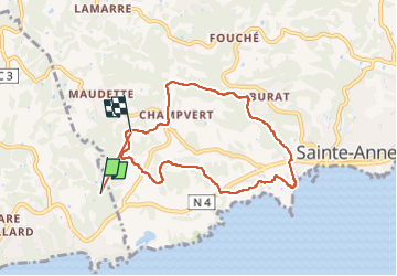

Length
10.7 km

Max alt
72 m

Uphill gradient
223 m
Km-Effort
13.6 km

Min alt
2 m

Downhill gradient
201 m
Boucle
No
Creation date :
2024-06-13 10:00:40.0
Updated on :
2024-06-13 11:48:52.273
1h34
Difficulty : Medium

FREE GPS app for hiking
 SityTrail
IGN / Geographical institutes
SityTrail Plus
The world is yours!
About
Trail Trail of 10.7 km to be discovered at Guadeloupe, Unknown, Le Gosier. This trail is proposed by sameja.
Description
Modette littoral st. Anne
Photos


Positioning
Country:
France
Region :
Guadeloupe
Department/Province :
Unknown
Municipality :
Le Gosier
Location:
Unknown
Start:(Dec)
Start:(UTM)
668422 ; 1793850 (20Q) N.
Comments